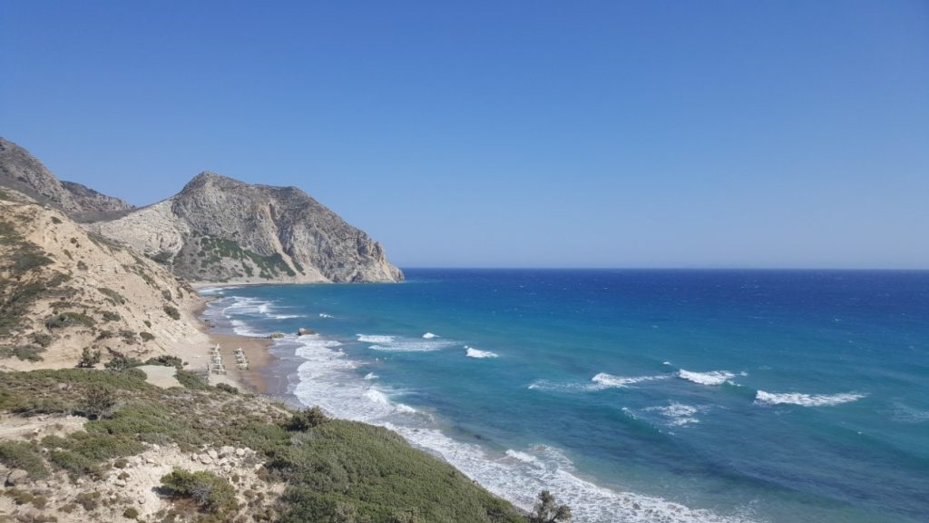
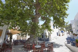
Tinos, alternative activities, tour of the mountain villages
On her island Of Tinos a large one has been recorded Paths network, 270 km, of which 120 km is Paths of Cultural Interest, which are mainly found in mountain villages of Tinos.
Information, Municipality of Tinos, tel. : 22833 60100, www.dimostinou.eu and for the Mapped Paths of Tinos, www.tinostrails.gr.

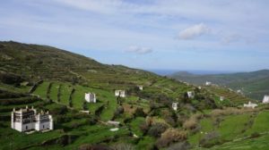
The old cobbled paths pass through mountain villages, from fertile valleys, next to the stone terraces of the fields or follow the old carriage road of the island.
Interesting hiking trails, according to the Municipality of Tinos, They are:
- Falatados-(Myrtle)-Magnanari-Plati-Livada-Livada Coast
- Xinara-Xombourgo-Koumaros-Skalados-Krokos-(Περάστρα)-Baths-(Kampos-Tarambados-Smardakito)
- Monastery of Kechrovouni-Mountados-Sperados-Tripotamos-Xombourgo-Karya-Tzados- Kechrovouni Monastery
- Kionia-(Χατζιράδος)-Ktikados-Smourdia-Vary-Poles-Chora
- Falatados-Kathlikaros-Volax-Griza-(Sklavochori)-Love
- Steni-Potamia-Marouli-Lychnaftia
- Myrtle (Almasuria or Saint Isidore)-Prophet Elias-Tsiknia Peak
- Two Villages-Mandalou-Faneromeni Monastery-Kounares-(Saint Barbara)-Saint Sostis
- Cardiani-(Giannaki Bay)-Hysteria-(Ysternia Bay)-Tower-(Panormos)-Marlas-Mamados
- Beauty-(Karkados)-Aetofolia-Koris Pyrgos-Stavria-Katapoliani Monastery-Plateia-(Pyrgos-Agia Triada)-Ροχαρη
- Kionia-Agia Marina-Kardiani-(Saint Minas)-Second Finding-Ysternia
- Arnados-Kechrovouni Monastery-Vani-Dirafia-Kokkina-Marmaries-Chora (Monastery of Agia Paraskevi)
TINOS RUNNING EXPERIENCE

Each year, beginning of June, the matches take place, IMIMARATHONIOS (21 Km), TINOS FUN RUN (5 km) and TINOS FUN RUN (10 km). Also includes races, TINOS KIDS RUN (900 m.), for children and the SPECIAL RUN (100 m.), for the disabled.
The races have also included Tinian Trail :
Tripotamos – Mountados – Cowhide – Tinos Town (6,5 km, duration 3,5 hours, easy route). The winners receive as a prize a faithful copy of the medal of the games "ΤΗΝΙΑ 1895», in remembrance of the games "Tinia"of 1895. In the end it is organized Pasta Party with local food, by the women of the island, local wine, raki and island feast . Information : www.tinosrunningexperience.gr and Merchant-professional & Tinos Craft Association.
THNOS CHALLENGE
- THE Mountain Running Race, Tinos Challenge, included in Cyccharging Trail Cup, done every year (usually in December or early January. Information : https://cycladestrailcup.com and www.tinos-challenge.com , tel. : 6941508016.
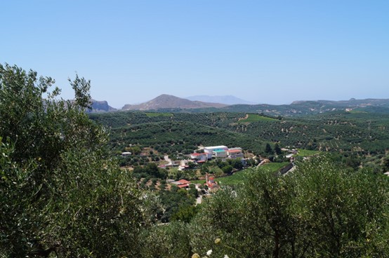
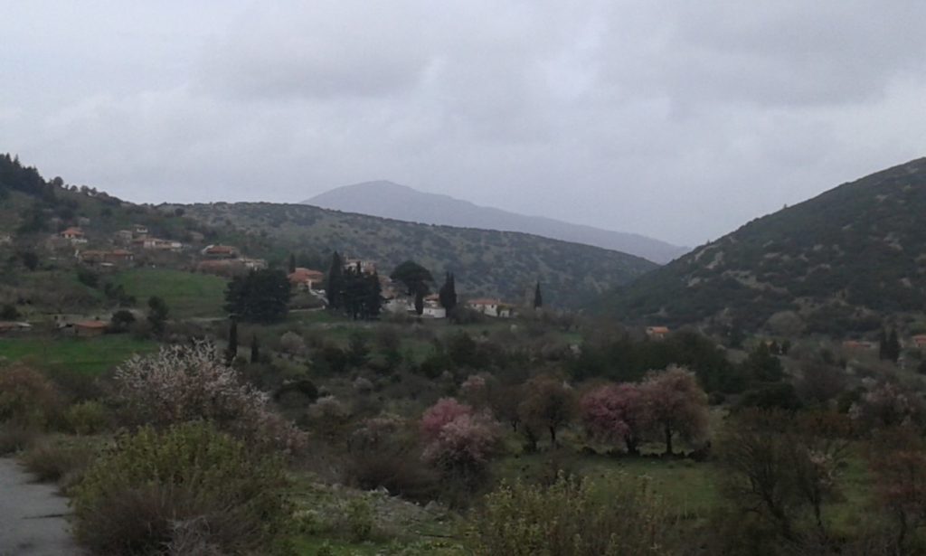
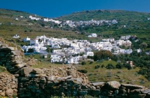
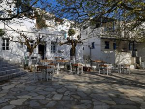
MOUNTAIN VILLAGES OF TINOS
HIKING ROUTES - ALTERNATIVE ACTIVITIES
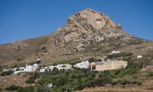
- EXOMBURG
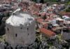
The settlement owes its name to the rocky hill Exomburg or Xomburgo (640 m.). The Castle of Xombourgos, was located on this granite rock. When the Turks, they burned the whole city, which had been developed inside the Castle, the few inhabitants left, created a new settlement, outside the Castle (Italian : borgo), Xomburgo.
For climbing :
On the rock of Xombourgos, in good quality granite, which includes walls, slots, negatively, roofs, geometric dihedrals etc.. they have opened 55 short "one rope" routes and 7 trails 'two ropes', with a degree of difficulty ranging from 5a to 7b +, with major difficulties in 6a-6c. All routes are fully equipped, with stainless steel plugs - rings placed using resins. The rock of Xombourgos is high 640 m. and is located in the middle of N.. part of the island.
For hiking :
There is a path that passes through the villages : Xinara- Xomburgo-Koumaros-Skalados-Krokos-(Περάστρα)-Baths-(Kampos-Tarambados-Smardakito).
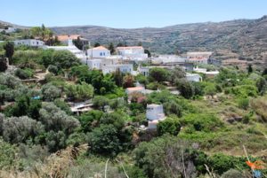
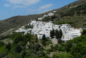
- ΜΟΥΝΤΑΔΟΣ
It is located on the slope of Kechrovouni, in the distance 8 km from Chora, Picturesque village, with white traditional houses, cobbled streets and a stone bridge. The painter and engraver came from Mountado Ioannis Platis or Platis (1833 – 1928).
For hiking :
Mapped path T1 : Chora-Xomburgo-Mountados-Chora (13,1 km)
- ΚΟΥΜΑΡΟΣ
Small medieval village, with few inhabitants, in the distance 10 km from Chora. The Theater Kumara They are known for their summer events.
For hiking :
Mapped path M4A : Agapi-Sklavochori-Skalados-Koumaros (4,6 km).
- BATHS
It is located in a verdant ravine, 11 km from Chora.
For hiking :
Mapped path M4B : Perastra-Komi-Tarambados-Loutra (6,3 Km).
- ΤΡΙΠΟΤΑΜΟΣ – ΣΠΕΡΑΔΟΣ
THE Tripotamos, is built on 3 ποταµούς, under the rock of Xombourgos. It is located at the crossroads of the road that leads to Above Parts, Bottoms and Outside Parts, just a distance away 4 Km from Chora. The village stands out for the vaulted alleys, in their labyrinthine form reminiscent of a castle. at Tripotamos the Cheese Factory of the Agricultural Cooperative of Tinos (grotinos.gr, tel. : 2283 021184) with local products of Tinos, such as milk, gruyere, mizithra, "Cheese", butter etc.. and a pottery workshop.
The famous confectionery workshop of Tinos «HALARIS SA.»Is located in Tripotamos. Try Tinos macaroons, "Nougat of Halaris", "Stingy" (the well-known "lychnaraki" with Tinos cheese) etc.. (www.halarisgroup.com ,tel. : 22830 21152)
THE Σπεράδος, is a small settlement, with few houses, belonging to Tripotaios.
For hiking :
Mapped path T1B : Tripotamos- Sperados-Mountados (1,9 km) or the traditional cobblestone path, Tripotamos (Smourdia) - Country.
- XINARA
mountain village, built under its hill Xombourgou. In the small Xinara Theater, summer events take place.
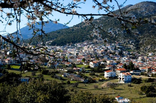
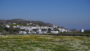
- ΚΑΡΔΙΑΝΗ
Village with lush vegetation, traditional island houses and great views of Giannaki Bay. Kardiani is famous for its sunset, to Ormos Giannakis (Καρδιανής).
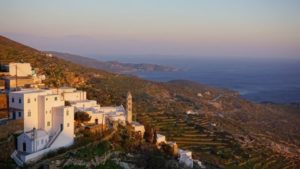
For hiking :
Mapped path E1 :Giannaki Bay- Kardiani-Ysternia-Ormos Isternion– Giannaki Bay (14,2 km)
- HYSTERNIA or ISTERNIA
Is located 3 km after Καρδιανή and 23 km Δ. of Chora of the island. Name Hysteria due, according to one version, in the latter = last, as the village was the last to reach the carriage road once. According to another version, from the cistern = tank, which finally happened Isternia. The village was the 2The more important marble center on the island, after the Panormo, That is why the houses have a lot of marble decorations.
For hiking :
Mapped path E1A : Ysternia-Platia - Pyrgos (2,7 km).
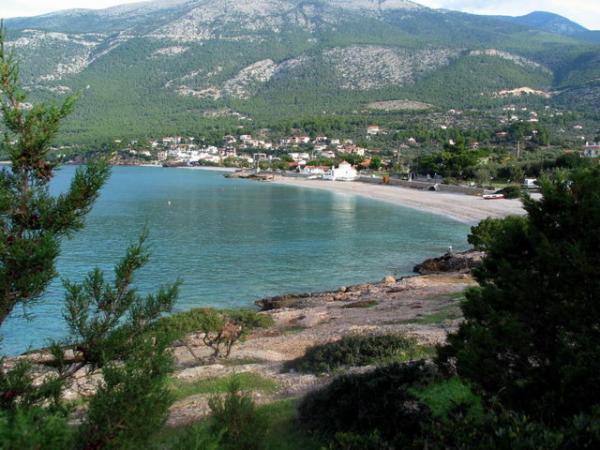
- TOWER
THE Tower is the largest village of Tinos and you will find it in the NW. Island's, after Hysteria.
For hiking :
Mapped path E2 : Tower - Panormos-Rochari-Platia - Tower (5,8 km).
- ΦΑΛΑΤΑΔΟΣ
It's the 2The largest village of the island and is far away 11 km from Chora. The area is famous for the production of raki and wine.
For wine tourism :
The Winery «Volacus Wine», with organic vineyards, is located in Gardari, Falatados (distance 3.5 Km, after the village), tel. : (+30) 6978 485671, off from 1or June- 10 September, Wednesday- Sunday hours, 18:00 -20:00, by agreement, https://www.volacuswine.gr .
You can taste wines in a landscape full of granite rocks, the "volakes".
For hiking :
Mapped path M2 : Volax-Falatados-Myrsini-Volax (8,7 km).
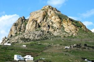
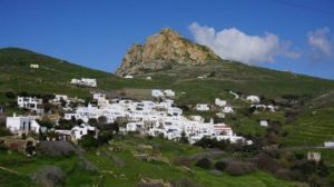
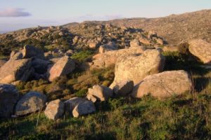
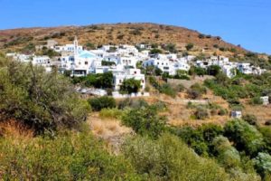
- ΒΩΛΑΞ
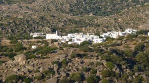
Impressive mountain village, built in 284 m., full of round granite rocks, their 'bolls». You will reach the bypass road, 1 km after the village Kumaros. At the village, even today, The residents, also deal with basket weaving. Ask to see the basket weaving workshops of Antonis, of Louis Sigalas etc.. In the small outdoor Volax Theater, the summer, theatrical performances are organized, children's performances with Karagiozi, speeches etc..
For bouldering :
Climbing low rocks without ropes, at the village Βώλαξ.
For hiking :
Mapped paths :
M2 : Volax-Falatados-Myrsini-Volax (8,7 km),
M4 : Volax-Agapi-Perastra-Exomburgo-Volax (12,1 km) and
M2A : Boundary Formations-Geodetic (1 km).
- ΚΟΜΗ
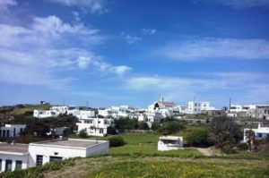
It 's in the Livadi Valley, 12 km from Chora and is one of the largest villages on the island. It impresses with its traditional architecture, with white houses, streets with arches, stone public fountains, orthodox and catholic churches, traditional cafes.
For hiking :
Mapped path M4B : Perastra-Komi-Tarambados-Loutra (6,3 km).
- LOVE – SKLAVOCHORI
OR Love is one of the oldest villages of Tinos and is just a stone's throw away 2 km from the village Com. It stands out for the architecture of the houses, traditional arched streets and natural sources.
The Sklavochori is built at an altitude 200 m. The great painter Nikolaos Gizis, (1842 – 1900) was born in Sklavochori, Tinos, by peasant parents. The sketches he made with charcoal, depicting villagers in agricultural work, livestock, plants etc., are located at Museum of Tinian Artists.
For hiking :
Mapped path M4A : Agapi-Sklavochori-Skalados-Koumaros (4,6 km)
- BEAUTY – AETOFOLIA – ΚΑΡΚΑΔΟΣ
OR Beauty is located in the North. Island's, in Livadi Valley, to Bottoms. Her old name was Cell(λ)ιά, perhaps from the cells of the monks that were in Monastery of Agia Yapokoi (Agia Pakli). Traditional village, with Cycladic architecture and dovecotes. OR Beauty participates in Tinos Food Paths, the Gastronomy Festival which takes place in May on the island (information www.tinosfoodpaths.gr ).
OR Eagle's nest is a small village, NW. Island's, built at an altitude 114 m. The village is known for the tradition of ceramic art, which is why it is organized in September Traditional Ceramics Festival (information, Aetofolian Association). It has also been created Museum of Traditional Ceramics of Tinos (open from July-September).
The village Karkados is located after Beauty, in the distance 13,5 km from Chora. You will see church of the Transfiguration of the Savior (1854), with the bell tower has taken a slope, also known as "H. Little Pisa of Greece».
For hiking :
Mapped path M5 : Kalloni-Aetofolia-Kalloni (4,7 km) or from the old road : Eagle's nest – Karkados - Kalloni.
- PLAIN
It is built in a fertile valley, near the village Tarabados. Located in the center of the island, in the distance 6 km in Chora. You will also see the Museum Costas Tsokli (2011), of the well-known visual artist, in the old primary school (www.tsoclismuseum.gr, tel. : 22830 51009, off from 1or June-September 30, except Tuesday, 10 am-2 p.m.. and 6 pm-9pm and Holy Week).
- ΤΑΡΑΜΠΑΔΟΣ
It is built in the fertile valley, like the village Plain and is 7,5 km from Chora. The village, one of the oldest on the island, is famous for them 20 protected pigeons of, unique examples of Tinian architecture. They are scattered in the valley and you will get there walking from it cobblestone path (during 20 ').
- RIVERS
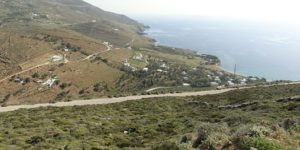
It is 13 km from Chora and is built in a fertile valley. Watermills once operated here, due to the many waters.
For hiking :
Mapped path T3 : Rivers-Lights (beach)-Rivers (7,8 km) or alternatively you can follow the path that reaches Santa Margarita beach.
- NARROW
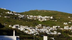
Located northeast. Island's, to Top Parts, in altitude 410 m. The village was created by the gradual merging of two smaller settlements, the panache and Sporado. It's the 4The largest village of the island and you will find restaurants-cafes and many shops.
For hiking :
Mapped path M1 : Steni-Karya-Xomburgo-Steni (8,3 km) and the old paths, Steni - River- (Lettuce)- Santa Margarita (beach), S.τενή -Rivers- Lamps (beach), and the path leading to peak of Tsiknia (713 m.).
- ΑΡΝΑΔΟΣ
It is built at an altitude 450 m., in A. of Kechrovouni Monastery, 7 km from Chora. It stands out for the impressive medieval architecture of the houses, the vaulted streets and the historic fountain (1823),in the upper square. In the Arnadou Exhibition-Cultural Center, painting exhibitions and cultural events take place.
- ΤΡΙΑΝΤΑΡΟΣ
Big village, organized, with small alleys, stairs, arches and a traditional olive press.
- TWO VILLAGES
Located in the SE. side of Kechrovouni, at an altitude of 450m., 9 Km NE. by Country. From here you will have a nice view to, the sea and the surrounding islands The settlements «Up Village" and "Kato Chorio»Joined in Two Villages. The village has many springs such as "Kato Xynari", with the age-old plane tree (1885). The wide marble staircase, post 100 steps, leads to the village square, with the cafe "Right after».
For hiking :
Mapped path T2 : Agios Ioannis Porto (beach)-Two Villages-Agios Sostis- Agios Ioannis Porto (12,5 km) and traditional path, Αρνάδος – Monastery or Αρνάδος – Τριαντάρος.
- KTIKADOS - KIONIA
The Κτικάδος is a traditional village with a nice view of the seaside Kionia. You will also see the old fountain with the stone washers.
For hiking :
Mapped path T1A : Chora-Kionia-Ktikados-Kyra Xeni (monastery in Panormos)
USEFUL ADDRESSES
- ΜΑΜΑLIS TRAVEL, Rafina agency, tel. : 2294 022292, www.mamalistravel.gr